Quick Navigation
- Orkney's Sea Cliffs at a Glance
- The Old Man of Hoy — 137 metres of red sandstone
- St John's Head — the sheer wall north of the Old Man
- Yesnaby Cliffs — the West Mainland's open-air geology lesson
- How to read an Orkney cliff face
- Marwick Head and the Cliffs that Roar in Summer
- Further north — Noup Head on Westray
- The Gloup — Geos and Blowholes at Mull Head
- Coastal Walks, Access and Safety
- Cliff-walking safety
- Frequently Asked Questions
- How tall is the Old Man of Hoy?
- What is the tallest sea cliff in Orkney?
- How do you get to the Old Man of Hoy?
- Are the cliffs safe to walk along?
- What is Yesnaby Castle?
- When is the best time to see seabirds on the cliffs?
- How old is the rock that the cliffs are made from?
- Sources & further reading
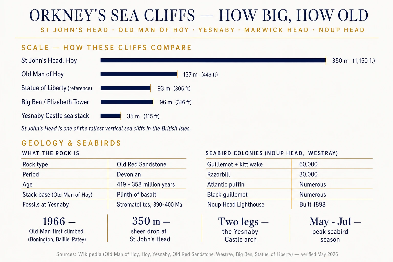
Orkney's coastline is one of the great geological theatres in the British Isles. The Old Man of Hoy stands 137 metres clear of the Atlantic; just north of him the cliffs of St John's Head rise around 350 metres from the same water — among the tallest vertical sea cliffs in the UK. The rock under your feet is Old Red Sandstone, deposited when Orkney sat near the equator during the Devonian: the sandstone in those Hoy cliffs formed 380 to 370 million years ago, and the beds at Yesnaby on the west Mainland are older still. This is the guide to the cliffs themselves: what to look at, how big they really are, and where you can stand on a clifftop and see the lot.
Orkney's Sea Cliffs at a Glance
Five clifftops do most of the heavy lifting for visitors with limited time. Each is a different proposition — the world-famous stack, the highest sheer drop, the geologist's stop, the seabird theatre, and the blowhole that makes you stand back from the edge.
The Old Man of Hoy — 137 metres of red sandstone
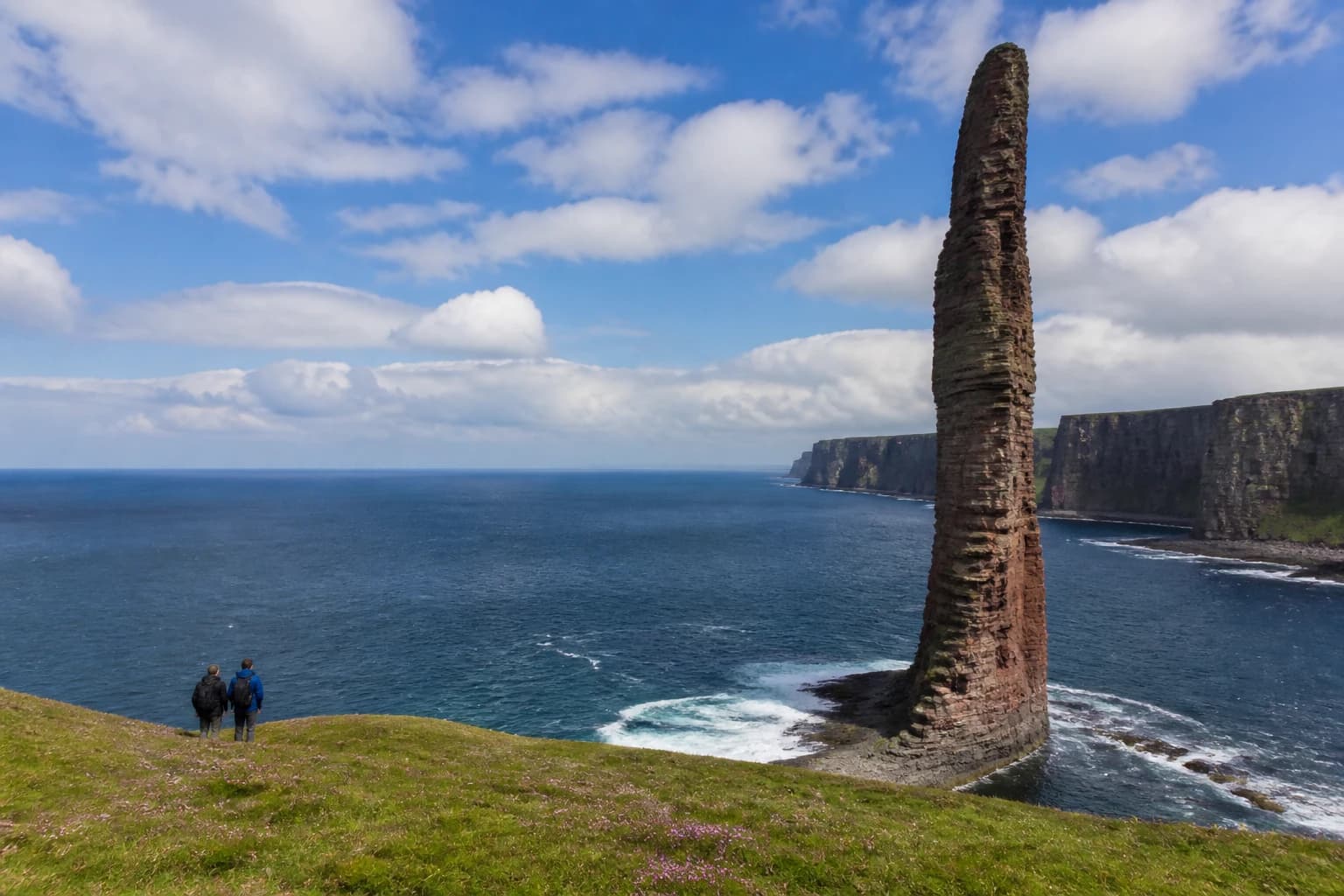
The Old Man is not just an Orkney landmark — it's the iconic sea stack in British climbing and BBC outside-broadcast history. He stands 137 metres (449 feet) tall, perched on a plinth of basalt that has so far refused to let him fall. The stack is a relatively young feature: 200 years ago, maps show a different shape entirely, and erosion will eventually take him too. Best viewed from the dramatic clifftop path leading from Rackwick Bay, a roughly three-hour return hike.
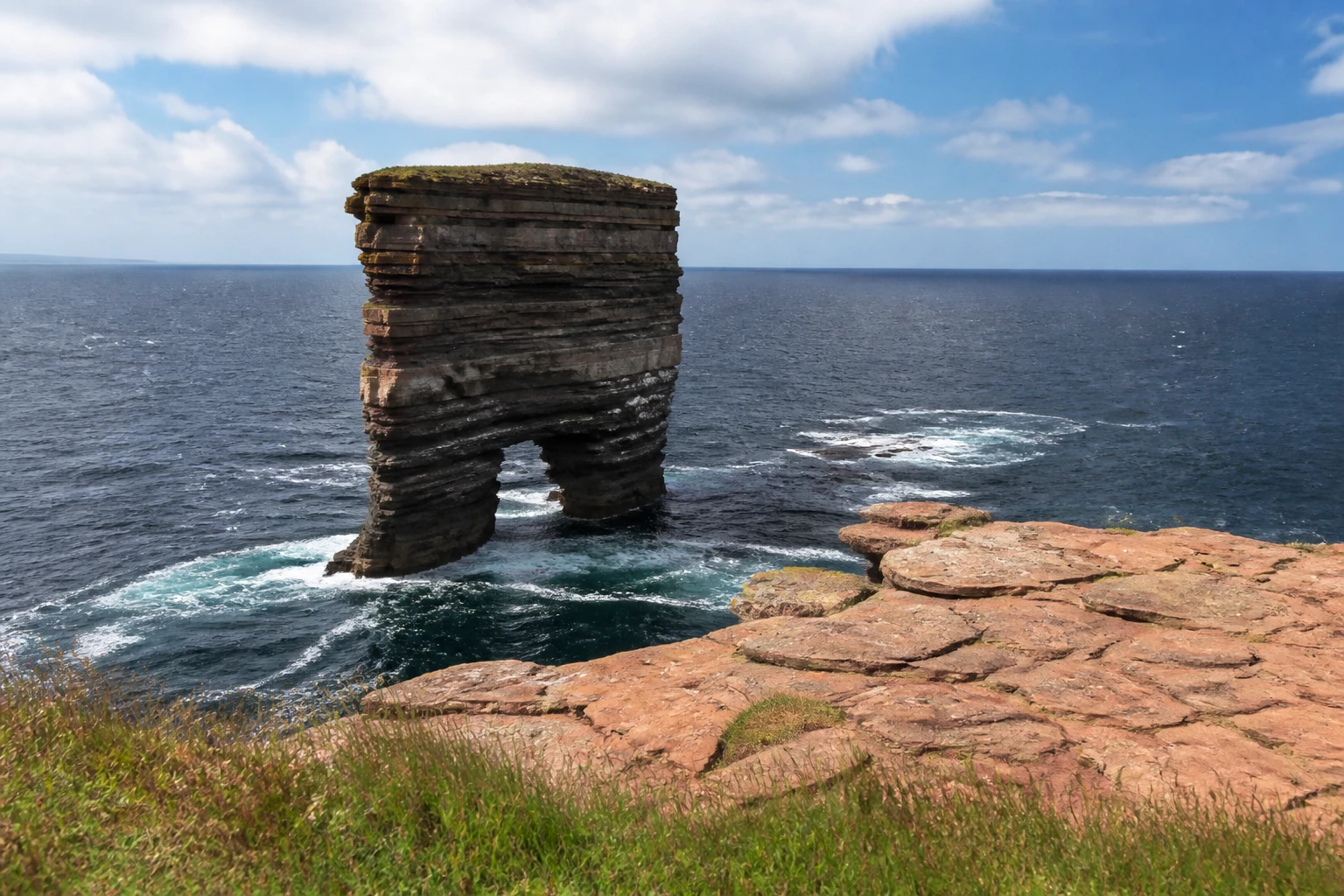
If you want to walk to the Old Man's viewpoint, the standard route leaves the road end at Rackwick Bay, climbs onto the cliffs by Moor Fea, and tracks west along the cliff edge with the Atlantic immediately to your right. For the wider context — getting to Hoy on the foot-passenger ferry, the Dwarfie Stane, where to eat — see our complete guide to the island of Hoy. Most visitors do the Old Man as a day trip from Stromness; the same Hoy ferry that takes walkers across also returns in late afternoon.
St John's Head — the sheer wall north of the Old Man
Walk an hour or so further along the cliff path beyond the Old Man and you reach St John's Head — one of the tallest vertical sea cliffs in the British Isles, reaching around 350 metres (1,150 feet) above the Atlantic. To put that in perspective: that's roughly three and a half times the height of Big Ben (96 m) and well over three times the Statue of Liberty (93 m). The Head is not a tourist viewpoint with railings — it's a sheer drop with nothing between you and the sea. Stay well back.
Planning your trip
Staying overnight? Compare live prices and availability across Orkney on Booking.com.
Compare Orkney staysWe earn a small commission if you book through this link, at no extra cost to you.
Yesnaby Cliffs — the West Mainland's open-air geology lesson
The cliffs at Yesnaby, on the west coast of the Mainland, are where Orkney's rock story is easiest to read. The layered Old Red Sandstone here was laid down in shallow lakes and on wind-blown desert dunes near the equator during the Lower Devonian, around 390 to 400 million years ago. Walk along the clifftop south of the Yesnaby car park and you can see fossilised lakebed ripples, mud-cracks, and the long sloping bands of wind-blown dune cross-bedding stacked one on top of another like the pages of an enormous book.
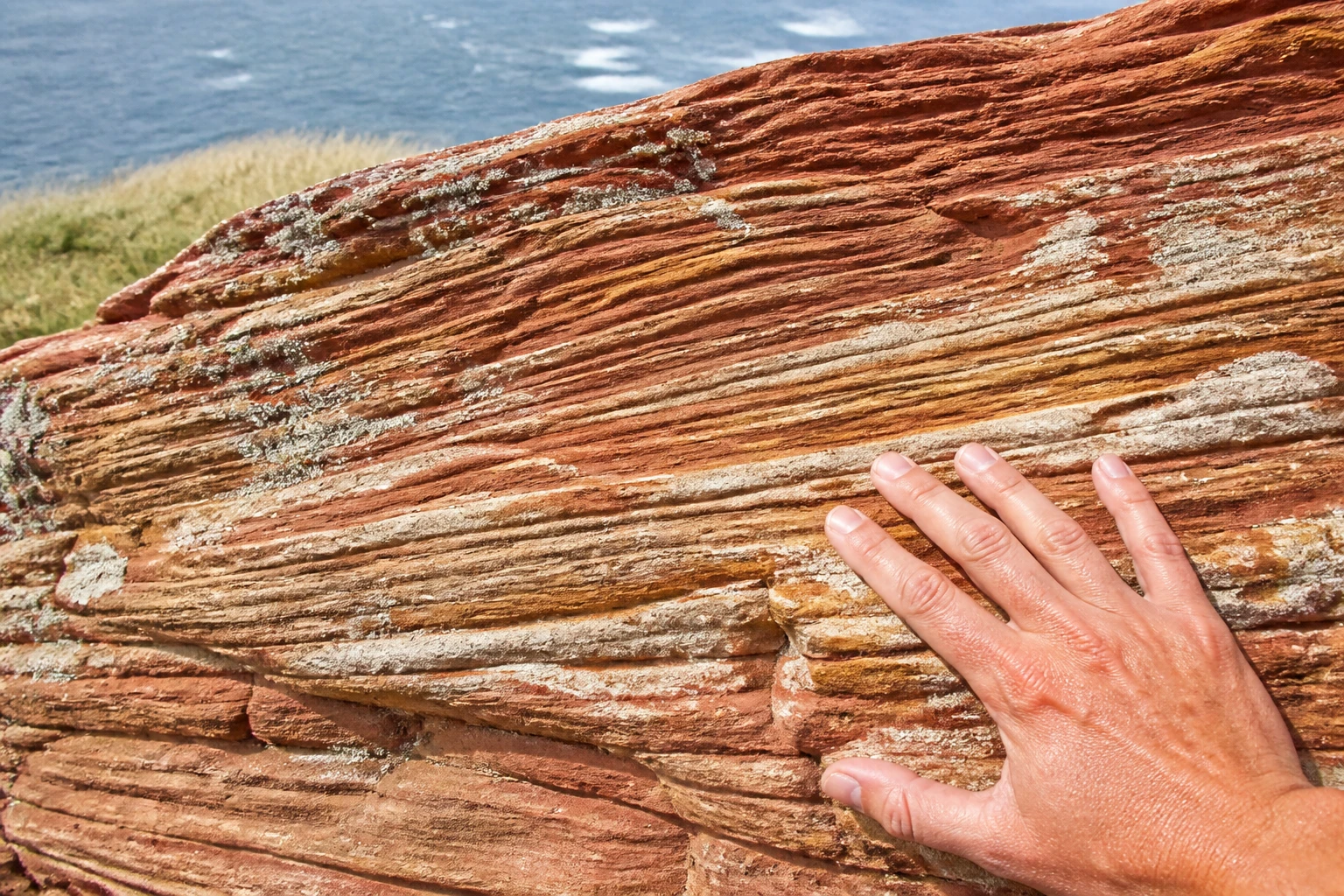
The headline rock here is Yesnaby Castle, a two-legged sea stack just south of the Brough of Bigging that Wikipedia describes as "sometimes a smaller version of the Old Man of Hoy". Around it, the cliff edge is punctuated by classic erosion features — sea caves, geos, arches, and the Broch of Borwick clinging to its remnant promontory. Park at the Yesnaby car park and turn south for the Castle; turn north for the more remote stretches towards the Marwick boundary.
How to read an Orkney cliff face
- Sea stacks — isolated pillars (like Yesnaby Castle and the Old Man of Hoy) left when arches collapse or headlands erode away around a resistant block.
- Geos — narrow, steep-sided inlets cut along faults and weaknesses in the cliffs by relentless wave action. Garthna Geo south of Yesnaby is a textbook example.
- Gloups — blowholes formed when sea caves collapse inwards, leaving a hole in the clifftop still connected to the open sea via a tunnel.
- Cross-bedding — the long sloping bands inside otherwise horizontal sandstone layers, fossilising the surface of wind-blown sand dunes.
- Stromatolites — layered fossil microbial mats locally called "Horse Tooth Stones", visible in the Yesnaby beds.
Marwick Head and the Cliffs that Roar in Summer
Drive north of Stromness in early summer and the cliff air gets loud. Marwick Head — an RSPB reserve on the Mainland's west coast — is one of the great seabird theatres of the British Isles. From May through July, tens of thousands of guillemots, kittiwakes, razorbills, fulmars and shags cram onto the narrow horizontal ledges of the sandstone cliff face, with puffins in smaller numbers. Park at the reserve and walk the cliff-top loop; the noise and the smell make their own case for the trip.
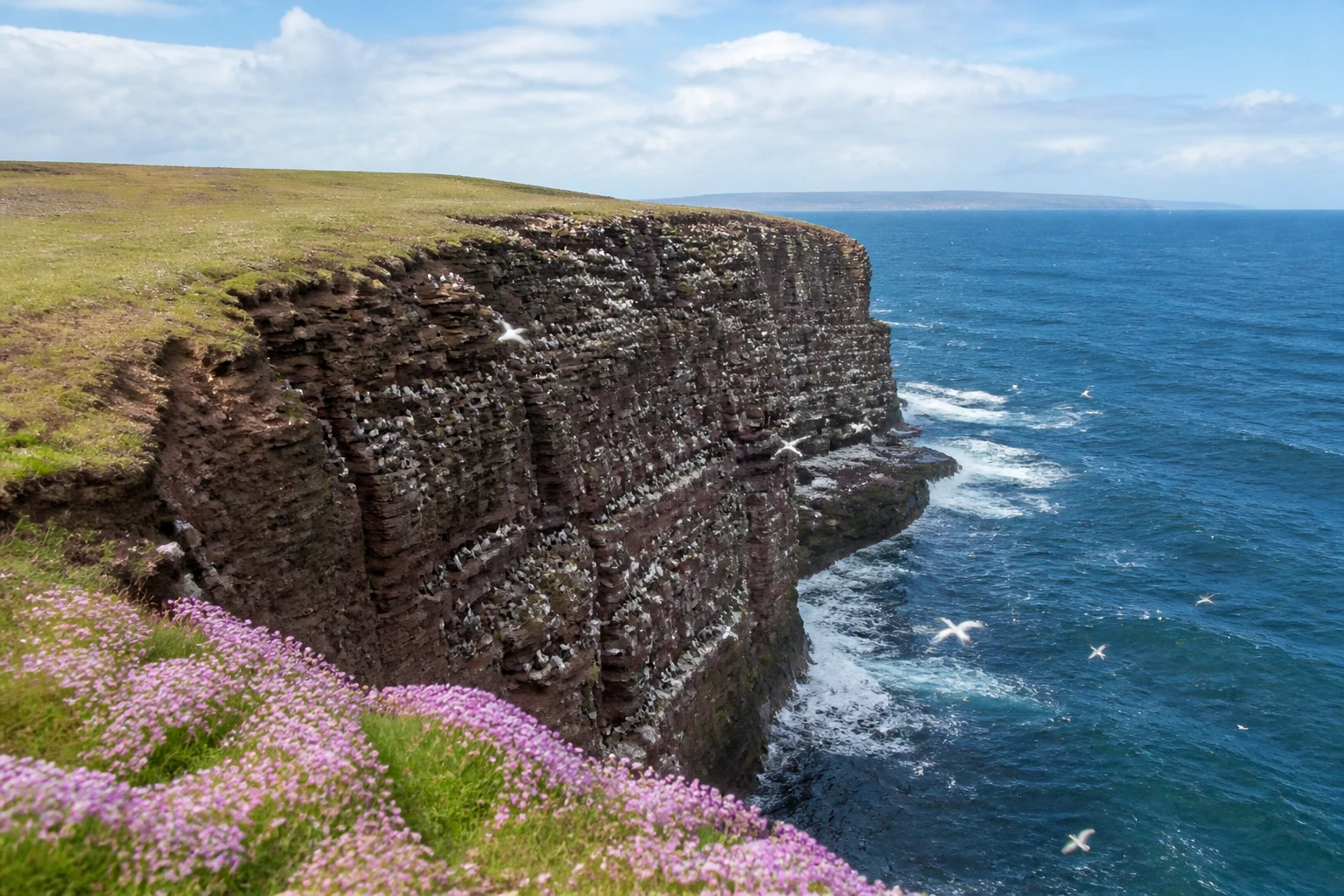
For a deeper read on what nests where and which months are best for which species, work through our companion piece on Orkney's seabird hotspots and seasonal calendar. The cliffs themselves are the stage; that piece is the cast list.
On the same headland, the Kitchener Memorial is a stone tower commemorating the loss of HMS Hampshire off Marwick Head in June 1916, taking Lord Kitchener and over 700 crew. The cliff path passes within yards of it; the memorial wall added in 2016 names every man lost. It's the most quietly moving stretch of cliff-walking in Orkney.
Further north — Noup Head on Westray
If you have a day and a ferry crossing in you, Noup Head on Westray is the biggest seabird colony in this guide: around 60,000 guillemots, with kittiwakes in comparable numbers again, plus razorbills, Atlantic puffins and black guillemots on dramatic west-facing cliffs. The 1898 Noup Head Lighthouse sits on the clifftop — one of several Orkney lights worth a stop on a Stevenson trail. Our piece on Orkney's clifftop lighthouses covers the built heritage side; this guide stays focused on the rock itself.
The Gloup — Geos and Blowholes at Mull Head
If you walk a single short cliff path in Orkney, make it the one at Mull Head on the Deerness peninsula. Ten minutes from the reserve car park you reach The Gloup — a vast rectangular collapsed sea cave that sits a surprising distance inland from the cliff edge, still connected to the open sea by a tunnel beneath your feet. On a big swell day, the chamber below booms like an artillery range.
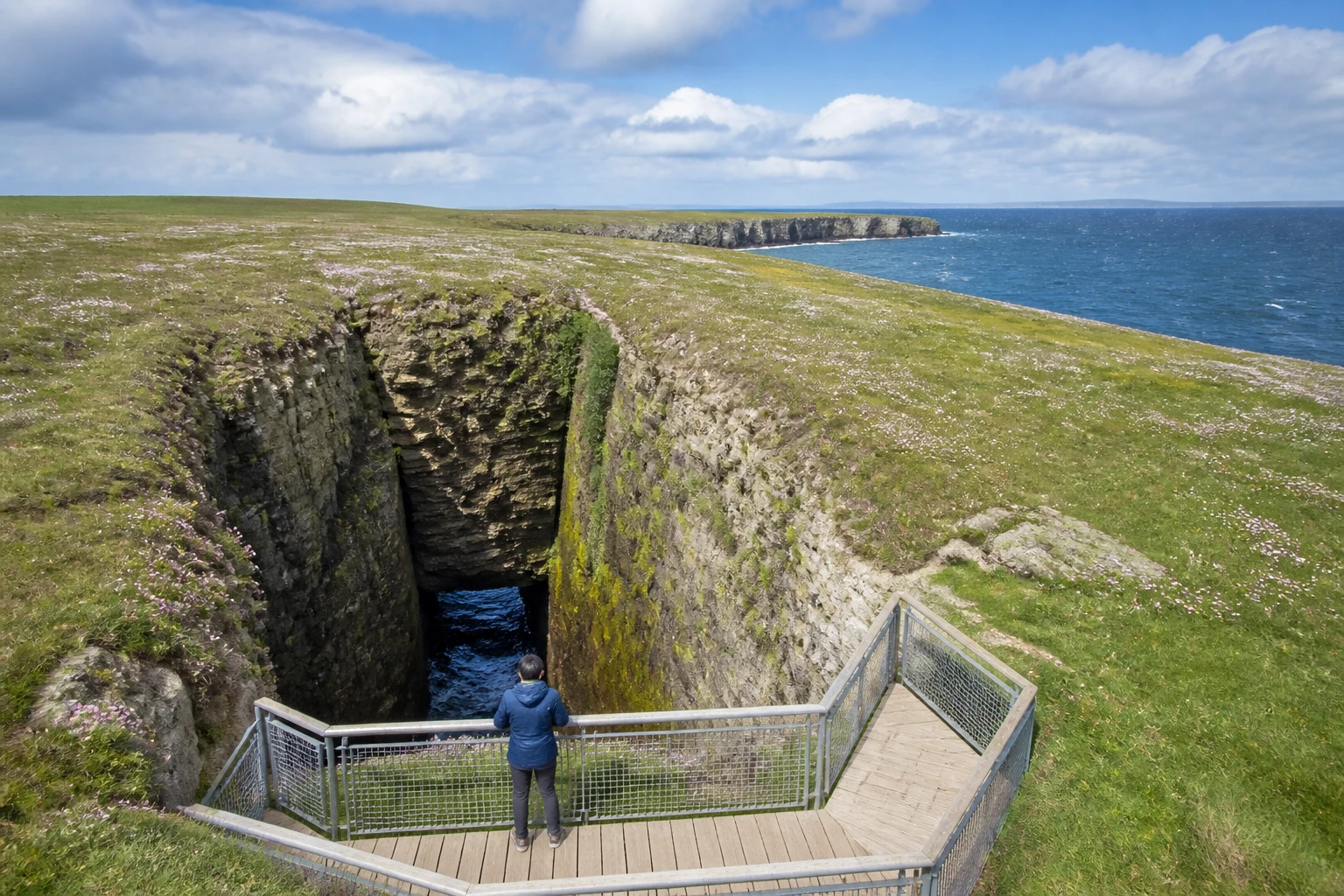
The fuller circular walk from the car park takes around 90 minutes and links The Gloup with the Brough of Deerness, a tidal stack that holds the remains of a tiny Norse chapel. It's an easy introduction to the geos, gloups, broch sites and seabird ledges of the Mainland's east coast — flat-footed in walking terms, jaw-dropping in scenery terms.
Coastal Walks, Access and Safety
Most of Orkney's headline cliffs are walking-access only — there's no bus to the Old Man, no car park at St John's Head. The good news: every walk in this guide is on a maintained or well-trodden path, and the longest is around four hours.
- Old Man of Hoy from Rackwick — ~3 hours return, ~200 m total ascent, moderate. Ferry to Moaness, road or shuttle to Rackwick, walk west.
- Yesnaby circuit — ~1.5 to 2 hours, easy clifftop, no steep ascent. Park at the Yesnaby car park; choose your direction.
- Marwick Head loop — ~1.5 hours, easy. Park at the RSPB reserve, walk the bay round to the Kitchener Memorial.
- Mull Head + Gloup + Brough of Deerness — ~1.5 hours circular from the Mull Head reserve car park. Almost flat, lots of sea on three sides.
- Noup Head, Westray — ~3 hours return from the Noup road end on Westray. Ferry day-trip from Mainland.
Cliff-walking safety
- Stay back from the edge. Orkney cliffs are actively eroding sandstone — the ground under your feet can be undercut and unstable. Keep at least 5 metres from any cliff edge.
- Boots and waterproofs. Sturdy waterproof hiking boots are essential. Pack waterproofs and warm layers regardless of forecast.
- Watch the wind. Orkney is one of the windiest places in the UK. Forecast winds above 30 mph make cliff-edge walking genuinely dangerous — reroute or postpone.
- Tides matter at the Brough of Birsay. The causeway floods twice a day; check tide tables before crossing.
- Tell someone your plan. Phone signal is patchy on Hoy and Westray; let your accommodation know your route and expected return.
- In an emergency, dial 999 or 112 and ask for the Coastguard. The What3Words app gives a precise location.
If you'd rather not walk to the Old Man at all, the easiest way to see it is by boat — many Stromness skippers run a sea-level pass beneath the stack on the right tide. A guided Hoy day trip bundles the ferry, the walk and the return into a single bookable package.
The cliffs are also the wildlife front line — seals haul out on the rocks below, porpoises and orcas patrol the firths, and otters work the intertidal zone at dusk. Carry binoculars and give yourself an extra hour at every viewpoint.
Frequently Asked Questions
How tall is the Old Man of Hoy?
The Old Man of Hoy stands 137 metres (449 feet) tall, making it one of the most photographed sea stacks in Britain. It's a red sandstone column perched on a plinth of basalt rock, first climbed by Chris Bonington, Rusty Baillie and Tom Patey on 19 July 1966.
What is the tallest sea cliff in Orkney?
St John's Head on the west coast of Hoy reaches around 350 metres (1,150 feet) — among the tallest vertical sea cliffs in the British Isles. The cliff drops sheer from clifftop to the Atlantic, with no ledges or terraces.
How do you get to the Old Man of Hoy?
Take the foot-passenger ferry from Stromness to Moaness on Hoy, then a road or community shuttle to Rackwick Bay (or the longer walk over Moor Fea), then a roughly 3-hour return cliff walk to the Old Man's viewpoint. Total ascent on the walk is around 200 metres. The path can be boggy after rain; sturdy waterproof footwear is essential.
Are the cliffs safe to walk along?
Yes, if you take precautions. Stick to marked paths, stay at least 5 metres back from the edge, wear sturdy waterproof boots, and check the wind forecast — high winds make Orkney clifftops genuinely dangerous. There are no railings along most cliff edges; the only railed viewpoint in this guide is The Gloup at Mull Head.
What is Yesnaby Castle?
Yesnaby Castle is a two-legged Old Red Sandstone sea stack just south of the Brough of Bigging on the west coast of Orkney Mainland. It is sometimes described as a smaller cousin of the Old Man of Hoy, with a similar layered red sandstone composition and a distinctive archway through its base.
When is the best time to see seabirds on the cliffs?
May to mid-July, with late May and early June the peak. Guillemots, kittiwakes, razorbills, fulmars and puffins are all on the cliff ledges during this window. By August most birds have fledged and left.
How old is the rock that the cliffs are made from?
Orkney's sea cliffs are mostly Old Red Sandstone, deposited during the Devonian period roughly 419 to 358 million years ago. Fossil stromatolites in the Yesnaby beds have been dated to between 390 and 400 million years old — the same age the rock was being laid down at the equator.
Plan a few clifftop days, base yourself in one of the holiday homes and apartments in Stromness for quick ferry access to Hoy and short drives to Yesnaby, Marwick Head and Birsay, and you'll see more dramatic coastline in three days than most UK destinations offer in three weeks.
Sources & further reading
The facts in this guide were checked against the following authoritative sources.
- Hoy Orkney — St John's Head — cliff profile (this source gives the lower 335 m figure)
- Scottish Geology Trust — north-west Hoy geology — cliff height (350 m), Atlantic aspect and Hoy sandstone age
- RSPB — Noup Cliffs reserve, Westray — Westray seabird colony